

An area of low pressure being monitored in the western Gulf developed into a tropical depression Saturday that forecasters said could strengthen into a tropical storm by the time it makes landfall in Mexico.
According to the National Hurricane Center, as of late Saturday night the tropical depression was centered about 80 miles east-northeast of Veracruz, Mexico, moving west-northwest at 8 mph. It was forecast to becoming a tropical storm before making landfall in Mexico, which was expected to happen Sunday night. It had maximum sustained winds of 30 mph.
If it does reach tropical storm status, which would be under the name Tropical Storm Barry, it would become the second named storm of the Atlantic hurricane season after Tropical Storm Andrea.
CBS News Miami 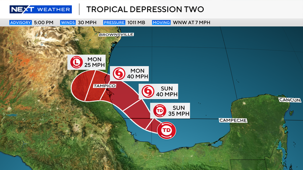
The hurricane center started issuing advisories on Tropical Depression 2 at 5 p.m. Eastern Time Saturday. An Air Force Reserve reconnaissance aircraft was able to find a closed circulation with winds of only 30 mph. The storm has shown better organization along with a well-defined circulation.
A tropical depression is defined as a tropical cyclone with maximum sustained winds of 38 mph, according to the National Weather Service, and becomes a tropical storm when it reaches 39 mph.
The storm will continue to move west-northwest over the rest of the weekend and is forecast to move inland over Mexico on Monday.
Tropical storm warnings have been issued for the Gulf coast of Mexico from Boca de Catan south to Tecolutla. Tropical storm force wind are expected, along with heavy rain, along the coast and over inland Mexico Sunday and Monday.
The Mexican states of Veracruz, San Luis Potosi and Tamaulipas could see rainfall totals ranging anywhere from 3 to 10 inches of rain, the hurricane center said.